


MapPath Pro app for iPhone and iPad
Developer: Julien Rozé
First release : 27 Mar 2012
App size: 13.9 Mb
MapPath is an easy-to-use app allowing you to record your trips.
It displays your track, your position and live information such as your speed, altitude or average speed.
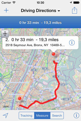
MapPath is also an utility that allows you to establish directions, measure distances, surface areas and perimeters by dragging pins (points) on the map.
- record your run: time, distance, altitude, speed, average speed
- pause and resume recording as needed
- display your track on the map
- display charts of your altitude, speed and pace
- location and heading tracking
- cut portion of the track
- display simultaneously several tracks on the map
- change color of each track on the map
- directions up to 30 steps
- measure distances, surface areas and perimeters using pins (points) on the map
- add point to your measure by taping and holding the map
- display simultaneously several measures on the map
- change color of each measure on the map
- import and export tracks and measures as KML, KMZ, ITN, GPX and CSV files
- gps accuracy options
- system of units options
- map types selection : Apple standard & satellite (3D) maps, OpenStreetMap, OpenSeaMap and custom maps
- options to show Traffic and Points of Interest
- Dark Mode
- Split View and Slide Over multitasking on iPad
- Widget displaying informations about your current location or current tracking
MapPath use iCloud to automatically keep in sync your tracks and measures across your devices.
If you have any problem, suggestion, please feel free to contact me at [email protected]
Note that continued use of GPS running in the background can dramatically decrease battery life.
Latest reviews of MapPath Pro app for iPhone and iPad
Great for tracking/recording local flights. Record track, altitude, speed, and duration of flight for future reference. Measure distance to destination prior to flight to calculate fuel stops and flight time. Would like to see Lat/Long degrees and decimal point option.
It does not display the recorded route. visible only when you save on your iphone6+
App messes up when trying to track a course. All the sudden blue tracker streaks away saying I traveled 21 miles In a straight line to who knows where. It doesnt just simply track ur travel path and give info. Big blue streak acrossy phone saying I went to toom buk too.
Absolutely perfect for what I was looking for — a way to show a KML file on my iPad. Thanks for a great app...
Works as advertised. I needed the ability to create perfectly circular shape files (not polygons) with a user definable radius and export them to other GIS software via KML. MapPath does this very well. Thank you.